There are only a few negatives to the system. First, you need an amateur (ham) radio license to operate a system like this. The test for the radio license is 35 multiple choice questions, and there are several places on the internet to learn about the questions and take practice tests. You only need a "Technician" level license to use this system, and since 2007 there is no morse code requirement to take the test. I found this site to be really useful to review the material. Tests are usually offered several times a month, and usually cost about $14 to take. If you can find a test site by the Laurel VEC , they don't even charge you to take the test!
The second negative with the system is that the ground stations (more on those in a minute) are completely run by non-paid hobbyists. That means that not all ground stations are operating all the time, and it is possible that some ground stations are configured improperly. There is also not 100% coverage over the entire United States. So it is possible to not be tracked at certain times/places. I'm OK with that, because I have the advantage of having my antenna several thousand feet in the air, which means that I have a better chance of reaching a ground station.
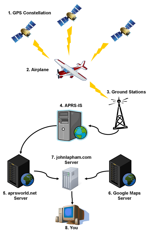
Now that I've covered the background to the technology, let me explain how the whole system fits together. Below are descriptions of the different systems that are depicted in the graphic to the right.
1. GPS Constellation
This is the same GPS system that it used all over the world. It is transmitting data that allows a GPS receiver to calculate its location in latitude, longitude, and altitude. What is not shown in graphic, but is used by my GPS receiver, is the Wide Area Augmentation System, or WAAS signal. That is using ground transmitters at known locations to improve the accuracy of calculated position in the GPS. Most GPS receivers are using this technology now. That is how your car GPS knows which side of the road you are on. The GPS network of satellites is maintained by the US Government, and is the only government run portion of the system.
2. Airplane
Inside the airplane is the heart of the tracking system. It basically consists of a GPS receiver and a radio transmitter. It takes the reported position of the GPS receiver, formats the data, and the transmits the "packet" of information to the ground stations. The radio transmissions are on the amateur 2-meter VHF band, on a frequency (144.39 MHz) reserved for APRS transmissions. I am using the Byonics Micro-Trak 8000 Frequency Agile radio. I have the radio mounted in a small electronics box, with an external GPS antenna, and an external transmitter antenna. The radio transmission is made "into the blind" and I have no indication if a ground station receives my data. This is why you will sometimes see missing points on a track.
3. Ground Stations
The ground stations consist of two different types of stations, repeaters and gateways. The repeaters, also called digipeaters, listen for APRS transmissions and the re-transmit the packet to the gateways. The internet gateways, also known as i-gates, receive the packet of information, decode it and send it to the APRS Internet Service over the internet. These stations are all operated by volunteer amateur radio operators.
4. APRS Internet Service
The APRS Internet Service, or APRS-IS, receives all the packets from the various i-gates, and streams the data out to whomever is listening. There are only about three or four core servers out there aggregating the information from the i-gates and then broadcasting it out to the internet. These servers are also run by volunteer amateurs. The APRS-IS does not archive any information, that is the function of the next system in the chain.
5. aprsworld.net Server
The aprsworld.net server falls into a category of servers I call "archivers". The basic function of these systems are to continually listen to the APRS-IS stream, and then archive them for later retrieval. I like using this database, because the interface to it is very flexible. Another, perhaps more popular, archive is findu.com. As with all of the other links in this change, these are also run by volunteers on their own dime.
6. Google Maps Server
Google has created a wonderful, free service using the technology it developed for Google Maps. Basically, it allows you to embed a map into your website, plot points and lines on it, and create a unique web application for your visitors. And they do it in really elegant manner. This is really the key technology that I use for the website. Without the ability to get easy to use, quality maps, I probably would not have set up this part of my website. Google Maps can do a whole lot more than I am using it for, but for my application it is perfect. Applications like mine are known as "mashups".
7. johnlapham.com Server
This is, of course, the website you are now visiting. It is hosted on a shared server connected to the internet with a high-speed connection. Besides serving up the static pages, like this one, it also dynamically creates the live tracking and recent flight tracks. I wrote several pieces of custom software to pull the information from both the aprsworld.net and Google Maps servers and display the information on my webpage. The software is written in php, javascript, and of course, html. Although there are already other web sites that can show an APRS track on a Google Map, I wanted to make a simple, clean interface that only showed my track with the information that is pertinent for my application of the APRS technology. Many sites try to be all things to all people, but that means either showing too much information, or making it difficult for users to get what they need.
8. You
This is your computer, the one you are reading this page on. Not only is your computer displaying the information I am sending from my server, but it is also running the timer to update the track and requesting new points, if there are any, from my server. It is also running the interface to the Google Maps parts. Because some of the software is running on the client computer, it gives dynamic web pages like this a snappy, real-time feel. This type of technology is called AJAX.
So that is how I am getting an almost real-time track of my plane into your computer. Still want to know more? Coming soon I will have The Nitty-Gritty...